
shadowcam.sese.asu.edu/images/1385
Preview meta tags from the shadowcam.sese.asu.edu website.
Linked Hostnames
7- 14 links toshadowcam.sese.asu.edu
- 4 links towww.lroc.asu.edu
- 1 link toquickmap.lroc.asu.edu
- 1 link tosese.asu.edu
- 1 link towww.kari.re.kr
- 1 link towww.nasa.gov
- 1 link towww.youtube.com
Thumbnail
Search Engine Appearance
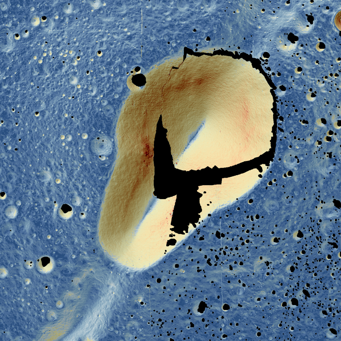
A Light Bulb Overhead
Colored to emphasize slope, with steeper slopes in red and yellow, and shallower slopes in blue, this digital terrain model (DTM) reveals the depths of a volcanic crater called Schrödinger G. The image merges an LROC Narrow Angle Camera DTM (NAC_DTM_SCHRODVENT_P752S1392) and a KPLO ShadowCam DTM (created from images M035062160S, M035097507S) at 7 m/pixel. Centered at 75.316°S,139.223°E, the image is approximately 11 kilometers wide. North is up. Colors indicate slope min: 0°, blue up to 14°, yellow and orange up to 38°, red through 64°. Areas without data are black [NASA/GSFC/KARI/Arizona State University].
Bing
A Light Bulb Overhead
Colored to emphasize slope, with steeper slopes in red and yellow, and shallower slopes in blue, this digital terrain model (DTM) reveals the depths of a volcanic crater called Schrödinger G. The image merges an LROC Narrow Angle Camera DTM (NAC_DTM_SCHRODVENT_P752S1392) and a KPLO ShadowCam DTM (created from images M035062160S, M035097507S) at 7 m/pixel. Centered at 75.316°S,139.223°E, the image is approximately 11 kilometers wide. North is up. Colors indicate slope min: 0°, blue up to 14°, yellow and orange up to 38°, red through 64°. Areas without data are black [NASA/GSFC/KARI/Arizona State University].
DuckDuckGo
A Light Bulb Overhead
Colored to emphasize slope, with steeper slopes in red and yellow, and shallower slopes in blue, this digital terrain model (DTM) reveals the depths of a volcanic crater called Schrödinger G. The image merges an LROC Narrow Angle Camera DTM (NAC_DTM_SCHRODVENT_P752S1392) and a KPLO ShadowCam DTM (created from images M035062160S, M035097507S) at 7 m/pixel. Centered at 75.316°S,139.223°E, the image is approximately 11 kilometers wide. North is up. Colors indicate slope min: 0°, blue up to 14°, yellow and orange up to 38°, red through 64°. Areas without data are black [NASA/GSFC/KARI/Arizona State University].
General Meta Tags
6- titleShadowCam • Seeing in the Shadows
- viewportwidth=device-width, initial-scale=1
- Content-Typetext/html; charset=UTF-8
- X-UA-CompatibleIE=edge,chrome=1
- csrf-paramauthenticity_token
Open Graph Meta Tags
5- og:titleA Light Bulb Overhead
- og:descriptionColored to emphasize slope, with steeper slopes in red and yellow, and shallower slopes in blue, this digital terrain model (DTM) reveals the depths of a volcanic crater called Schrödinger G. The image merges an LROC Narrow Angle Camera DTM (NAC_DTM_SCHRODVENT_P752S1392) and a KPLO ShadowCam DTM (created from images M035062160S, M035097507S) at 7 m/pixel. Centered at 75.316°S,139.223°E, the image is approximately 11 kilometers wide. North is up. Colors indicate slope min: 0°, blue up to 14°, yellow and orange up to 38°, red through 64°. Areas without data are black [NASA/GSFC/KARI/Arizona State University].
- og:imagehttps://shadowcam.im-ldi.com/ckeditor_assets/pictures/1463/content_schrodgfipSlope1.png
- og:urlhttps://shadowcam.im-ldi.com/images/1385
- og:typearticle
Link Tags
2- icon
- stylesheet/assets/application-92035de35328766c0a71a795abd084f7506dee6708a47f3e1e3c45aaa4eb0c48.css
Links
23- http://www.lroc.asu.edu/images/1207
- https://quickmap.lroc.asu.edu/?prjExtent=253423.6229785%2C-363357.1384827%2C325094.4496397%2C-310726.5736032&showGraticule=true&layers=NrBsFYBoAZIRnpEBmZcAsjYIHYFcAbAyAbwF8BdC0ypcOKbRFOOZLRfImqnioA&proj=27
- https://sese.asu.edu
- https://shadowcam.sese.asu.edu
- https://shadowcam.sese.asu.edu//twitter.com/intent/tweet?url=https://shadowcam.im-ldi.com/images/1385